
Field Surveying (LiDAR, GNSS, UAV)
- Namhoon Kim
- Mar 1, 2025
- 1 min read


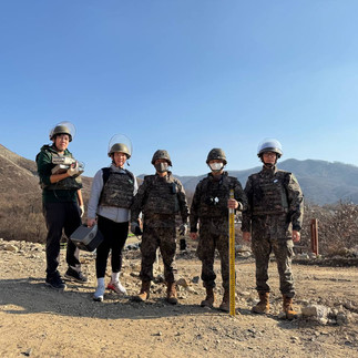


From November 20 to 27, 2024, I conducted field surveys in a somewhere in Gyeonggi-do for the Combat Experiment for Verifying Protection and Survivability Assurance of GP and GOP Units.
Every day, I acquired point clouds using the BLK360 LiDAR and performed ground reference point surveys using the Trimble R12i GNSS.
With the cooperation, I also conducted UAV photogrammetry, which allowed us to generate georeferenced orthophotos.
Additionally, I was able to numerically and visually analyze the combat experiment results using the point cloud data.
The environment was extremely harsh, making the survey challenging for both the equipment and the personnel.
However, in hindsight, it was a very meaningful experiment, and I am honored to have been a part of it.
There are many great memories of shared meals and coffee, leaving a lasting impression from this project.
Comments